Project team: Mahabir Pun, Dr. Bhushan Raj Shrestha, Prashant Manandhar, Gaurab Raj Upadhaya, Indiver Badal, Rajan Parajuli
Partner organizations: NARC Japan, KEIO University Japan, e-lab Japan, NREN
Project Period: September 2007 – August 2011
The climate change during the first half of the twentieth century has brought a tremendous impact on the high mountainous glacial environment. Many of the big glaciers melted rapidly and gave birth to the origin of a large number of glacier lakes. Out of 20 potentially dangerous glacial lakes in Nepal, 12 lie in this Khumbu, Mt. Everest Region. Glacial Lake Outburst Flood (GLOF) causes disasters to life and property along the downstream, results in serious death tolls and destruction of valuable forests, farms and costly mountain infrastructure. The recent catastrophic GLOF event in Nepal known as the Dig Tsho GLOF in 1985 has destroyed the Namche small hydro project, big amount of physical infrastructure and human lives. Accurate and timely information on the spatial locations and regular monitoring of the glacier lakes behavior is needed to prevent and monitor the GLOF hazards and assess the damages in the near future.Modern information tools such as Field Server with the integration of wireless technology, Remote Sensing and GIS could play a lead role in identifying potential risk lakes and monitoring the GLOF events in near real time. Field server has been played an effective equipment to gather potential information for the scientific prediction of GLOF. The early warning system is a potential safety method to reduce the impact of the ongoing disaster. It provides information earlier than the disaster happen.
The Everest region is one of the hotspots of glacial melting in the Nepal Himalayas. Out of 20 potentially dangerous glacial lakes in Nepal, Ima Glacial Lake is in most danger lake for Glacial Lake Outburst Flood (GLOF). A study conducted by the KEIO University Japan and International Centre for Integrated Mountain Development (ICIMOD) states that Imja is the fastest-retreating glacier in the entire Himalayas. Imja Lake, located at an altitude of 5200 meters in the Mount Everest region is expanding at an alarming rate. It is growing by 74 meters a year. Spotted as a group of small masses of snow in 1962, it has now turned into a one-square-kilometer lake.

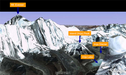
- To establish a real-time monitoring system using a mix of sensor and wireless technology
- To establish network infrastructure for researchers working in climate change
Real-time monitoring and early warning system have a diverse area of application such as flood monitoring, volcanic monitoring, earthquake and landslide monitoring etc. Field server (FS) plays an effective tool to provide proper information within a sudden time period. A fast-swelling glacial lake, is putting the entire Khumbu region in peril. When Imja Lake is burst, it will create a vertical tsunami tearing villages, mountain lodges, bridges, mountain paths, hydroelectric plants, world heritage woodlands, animal habitats, wildlife, livestock and most importantly innocent lives- from the slopes leading to the Mt. Everest.
This initiative of establishing wireless and sensor monitoring systems was made jointly by NARC Japan, Keio University Japan, the Department of National Park and Wildlife conservation, APAN Japan, e-Lab Japan. FS integration with Wi-Fi mesh is a self-monitoring device, powered by solar cells and capable of collecting a wide range of data on harsh climate conditions at the sites, as well as time-lapse images; captured by digital camera. FS as means of early warning system already had been installed on some areas of Khumbu region. Altogether there are five Field servers that are installed, one in Imja Lake 5200 meters, one near the high camp of island peak ridge 5300 meters, one in Sagarmatha National park office at Namche 3700 meters and two were installed at Namche bazaar 3400meter.
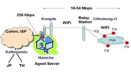
This FS provides different kinds of meteorological data such as temperature, humidity, pressure and Co2, water level etc with a time interval of 10 minutes, related to GLOF activities. All field servers in various place of this region which are connected through a wireless network and finally connect with VSAT at Namche Bazaar. NREN, with the collaboration of other organization extended, wireless networks LAN from the Namche village to the Imja Lake, the distancewas about 25 Km line of sight. These networks provided internet facilities in Dingboche village located at 4900 meters, Chukkung village located at 5000 meters. The Internet connectivity helped connect this rural region to the global arena. Similarly, early warning systems helped to notice the GLOF risk in advance at the downstream villages.
All FS were connected through a wireless network using Canopy Motorola for long distance. Two Relay Stations was installed, one at Namche (3400 meters) facing to Kongde Relay Station (4000 meters) and another at Chukkung-ri Relay Station (5400 meters) facing to Imja Lake using Deliberant Wi-Fi for short distance. For the redundant network, one relay station at Sagarmatha National Park office (3700 meters) had also been installed using Deliberant, and this wireless network was about 24 km far from the Chukkung-ri station. Another wireless network had been installed for villagers at Dengboche and Chukkung using Deliberant Wi-Fi. This uses low power microwave radio to link one or more groups of users together, or to provide a link between those places.
FS transmitted the data and picture through the wireless networks which was connected on VSAT at Namche. The FS started capturing images and several types of meteorological data that transferred real- time to a server located in Japan at http://fsds.dc.affrc.go.jp/data4/Himalayan.
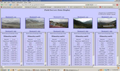
Second phase of this research project began on mid April 2008, installed new three FS, one in Sagarmatha National Park and another two FS near the high camp of Island peak ridge, which easily inspected the overall activities of the lake. The FS setup was undertaken in extremely difficult and adverse weather conditions. The FS started capturing images and several types of meteorological data that was transferred on real-time basis to a server located in Japan. The field server at different places forwarded the metrological data which included humidity, temperature, pressure, Co2, images
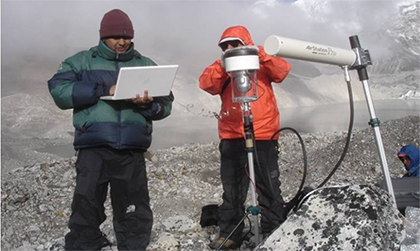
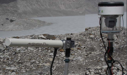
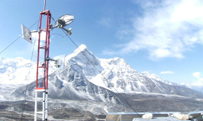
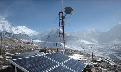
- GPS measurement on Chukkung-ri and surrounding of lake
Geographical positioning system was measured in Chukkung-ri nearby relay station and surrounding area of the Imja lake. It gave general information for measuring center access point of particular location. - Corner reflector installation
Additional corner reflector was installed on southern part of Imja, for measuring satellite picture of the lake since one corner reflector had already been installed on the ridge of western part - Water level sensor installation
Water level sensor was installed on the west ridge of the lake. Water level sensor had monitored the water surface of the lake on regular basis. It had played a major role to analyse the threats of glacier burst or some kind of potential hazards. - Measurement of outlet pond depth
Imja was semi-frozen when the team were planning to measure the centre depth of the lake. As a result, the research team had to measure the surrounding outlet pond depth with the help of boat. - Assessment of the status of end moraine
The research team had observed the end moraine status with the help of some scientific tools and was found that there was no big threat for few years.
- Wireless Network can be built to work in remotest areas.
- Low power self-sufficient devices embedded with appropriate sensors are needed to avoid big impact on fragile ecosystem.
- Power storing technology still needs more work for remotest areas.
- The major problem was power in this location . Without long lasting battery storage solar panels were worthless
- ICT technologies can help in monitoring and documenting environmental changes. It will also help in taking preventive measures.
- ICT can also increase the awareness in local communities about potential hazards
- A public private partnership between local communities, government, service providers and scientific researchers can only get the work done.
